A year has passed since the beginning of our project’s implementation, and after some hard-working months for the technical and scientific partners, the Karst Firewall 5.0 team is up with some exciting news !
We are happy to announce that the research activities have been pursued according to the plan, and the technical deliverables planned for this delivery period have been completed.
Study of the territory, climate change and wildfire risk
In April, the first two expert documents were prepared and signed by IUAV University of Venice (lead partner) and ZRC SAZU (Slovenian research partner). These are:
D.1.1.1 – Climate Change Assessment
D.1.1.2 – Wildfire Hazard and Vulnerability Assessment due to Climate Change
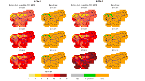
The first report provides a comprehensive overview of climate change in the Karst area, based on data from national meteorological agencies and open climate databases. The analyses confirm the trend: higher temperatures, longer summer drought periods, and greater amounts of precipitation in winter will directly affect soil moisture, forest stability, and consequently wildfire vulnerability.
“The results indicate that the forest on the Kras/Carso will face increasing heat and drought stress during the summer season increasing the vulnerability to wildfires due to low soil humidity, high temperatures and wooden necromass accumulation. The call for tight cross-border forest management is therefore ever so important, from the early stages of wildfire risk assessment to firefighting operations.” (p. 20)
The second report provides a more detailed analysis of the impact of climate change on the spatial distribution of wildfire risks. The results are concerning: most of the Karst area shows high or very high vulnerability. The model highlights the proximity of roads and railways, as well as human activity, as key factors of wildfire hazard.
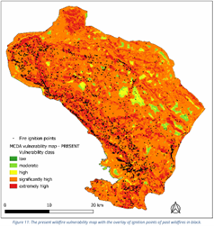
“The model identified distance to roads as the most influential predictor, followed by land use and distance to railways, highlighting the significant role of anthropogenic factors in wildfire hazard. (...) The spatial analysis revealed that high wildfire hazard areas are concentrated along the coast and near larger settlements with dense infrastructure. A significant proportion of wildfires (67.4%) ignited within 50 meters of roads, while 14.1% were near railways and 16.2% near settlements. Wildfires were most frequent in grassland and overgrown areas (39.8%) and deciduous forests (36.9%), underscoring the importance of fuel availability.” (p. 41)
Understanding the current and future hazard probability on the Karst territory is essential for the next steps of the project, such as the conceptualization of governance mechanisms to reduce the risk, and collaboration across the border for an effective and adaptive wildfire management.
Applying the research to practical management
In May, two more reports followed, focusing on the development of predictive models and their practical application:
D.1.2.1 – Predictive Algorithm Models
D.1.2.2 – Optimized Resource Allocation
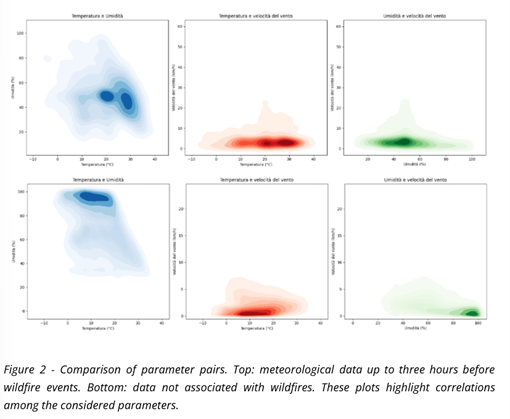
The reports are the result of collaboration between Infordata Sistemi Srl (a company specialized in data systems) and ZRC SAZU. Based on historical fire data and weather variables, advanced predictive methods have been developed, relying on machine learning.
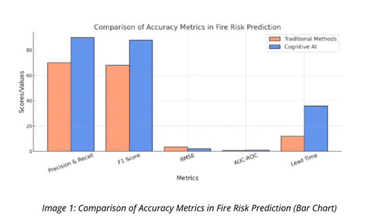
The Models of predictive algorithms, corresponding to the deliverable D.1.2.1, uses historical wildfire records and meteorological variables to create a dataset suitable for machine learning. An analysis was carried out and algorithms were selected for the prediction performance.
“Importantly, the application of Artificial Intelligence in this context adheres strictly to ethical standards and aligns with the principles of the EU AI Act, including transparency, human oversight, and accountability. While model outputs offer accurate predictions, they are not intended to replace human expertise. Instead, predictions serve as decision-support tools to be interpreted and validated by trained professionals such as foresters, civil protection agents, and local authorities.” (p. 5)
After the completion of the D.1.2.1, the partnership will finalise the next report named Optimized resource allocation: Guidelines and policy recommendations to use predictive models, corresponding to the deliverable D.1.2.2. This report draws on the results of the other documents and provides a unified framework for forestry departments and emergency responders.
It includes practical advice on how to best allocate resources using dynamic risk prediction (compared to traditional methods), the most efficient fire detection and fighting instruments to use in the Karst cross-border area, collaboration protocols, AI-integrated decision workflows, and draws general policy recommendations.
Conceived as a strategic guide to modernize wildfire management, this deliverable will be a support for decision-makers and stakeholders to make the Karst landscape more resilient against increased vulnerability and climate change.
“(The technological) evolution reflects a progression from generic, weather-based approaches to increasingly sophisticated, data-driven systems that integrate multiple data sources and methodologies. The current Karst Firewall 5.0 system represents the state-of-the-art in this progression, combining the strengths of previous approaches while addressing their limitations through integration and cross-border collaboration.” (p. 17)
The completed reports form the foundation for the next phase of the project, which includes tool testing, field validation, and the development of final policies and response protocols. All of this will contribute to greater resilience of the Karst landscape, which is increasingly threatened by climate change.