WABIN
Specific objective: SO 4 - Promoting climate change adaptation and disaster risk prevention, resilience, taking into account eco-system based approaches
Typology: Standard project
The WABIN project tackles the need, identified by the Italy-Slovenia Programme, to propose and implement specific interventions to promote adaptation to climate change, sustainable water management and protection of water and hydrogeological resources from economic, social and environmental perspectives. The cooperation area presents critical issues in terms of nonhomogeneity of water availability in time and space and water management inefficiency. This condition leads to alterations in natural hydrological regimes caused by excessive withdrawal pressure, a poor vision of water consistency and an intensification of the effects of climate change
- the WABIN project aims to promote the sustainable management of water resources and the protection of aquifers through the integration of methodologies applied at hydrogeological basin level with the support of water balance forecast models useful for obtaining reliable estimations on consistency and use of water resources.
- Promove the application of adequate and inclusive participation tools to intervene on adaptation to climate change and on the phenomena of contamination, waste and water risk.
Outputs envisaged in the WABIN project:
1) definition of the integrated methodological package for the characterization of hydrogeological basins to determine the production potential of natural water resources in relation to the effects of climate change, through the available datasets and those newly acquired in the cross-border context;
2) dynamic and scenario modelling of hydrogeological basins based on a conceptual hydrogeological model (in 3D) of the Isonzo basin (test site) to obtain the water balance and future forecasts on water resources, especially in relation to climate change. They are extremely useful for preserving the balance between water availability and demand and determining the safety margins for water storage and control;
3) identify the cross-border memorandum of understanding based on the establishment of a network and an action strategy for the protection, monitoring and management of water resources in hydrographic contexts, through public-private participation processes carried out jointly on the Italian and Slovenian borders;
4) encourage the active participation of citizens to inform, educate and raise awareness among the population about the protection of water resources, according to a sustainability scheme and conscious management of water, given its scarcity.
Particularly relevant will be the project outputs and related results, from which various target groups will benefit of:
1) the formal WABIN Partnership supported by the establishment of the public-private cross-border network of the memorandum of understanding for the protection, monitoring and management of the resource water at a hydrogeological level;
2) the conceptual hydrogeological and cross-border water balance model created with integrated water management methodologies;
3) the cross-border Memorandum of Understanding, a strategic document defined by the pilot actions which includes the identified territorial needs, existing good practices, integrated water monitoring and management methodologies for the definition of common planning objectives of the hydrographic districts on the basis of the policies of local development of the territories.
4) Education and awareness initiatives aimed at citizen’s participation. The focus is to transfer knowledge on the protection, monitoring and management of water resources in the various areas of use (civil, agricultural and industrial). Good practices for the risk of drought, floods, landslides and hazards will be addressed through contests for young people and citizen science initiatives.
The GIS
The GIS (Geographic Information System) developed within the WABIN project is a geographic information system that collects, organizes, and visualizes all the spatial data needed to describe the functioning of the transboundary aquifer of the Isonzo/Soča River Basin.The GIS forms the digital foundation of the project's hydrogeological model. It integrates data from geophysical surveys, hydrogeological measurements, lithostratigraphic information, geochemical, isotopic, and atmospheric datasets, transforming them into different georeferenced information layers, including points, lines, polygons, and grids.
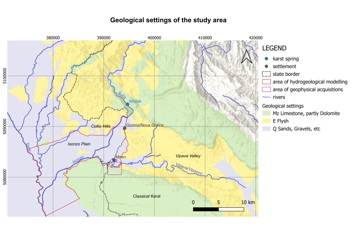
Topographical and hydrological settings of the study area
This overview map illustrates the topographic and hydrological characteristics of the study region. The map shows elevations ranging from 0 m above sea level (Lower Isonzo Plain) to over 1,400 m above sea level in the mountainous areas of the Trnovo–Banjšice Plateau. The Vipava Valley occupies an intermediate elevation within the study area.
The map highlights the river systems, the main karst spring, and the monitoring network used for surface water and groundwater observations. The data of the monitoring network provided important input data for the hydrogeological modelling. In addition to the topographic base map, the extents of the hydrogeological modelling area and the geophysical survey area are also indicated.
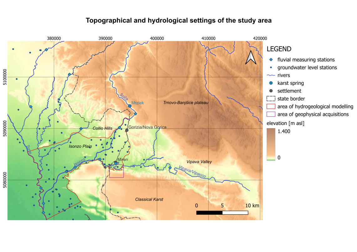
Geological settings of the study area
This map depicts the simplified geological setting of the study area surrounding the Soča and Vipava valleys. It highlights the main geological units: Mesozoic limestones and locally dolomites in green, Eocene flysch in yellow, and Quaternary fluvial sediments, such as sands and gravels, in grey. The geological map provides the essential framework for hydrogeological modelling and serves as a key reference for the interpretation of geophysical data and survey results.
Tracer tests - hydrogeological connections
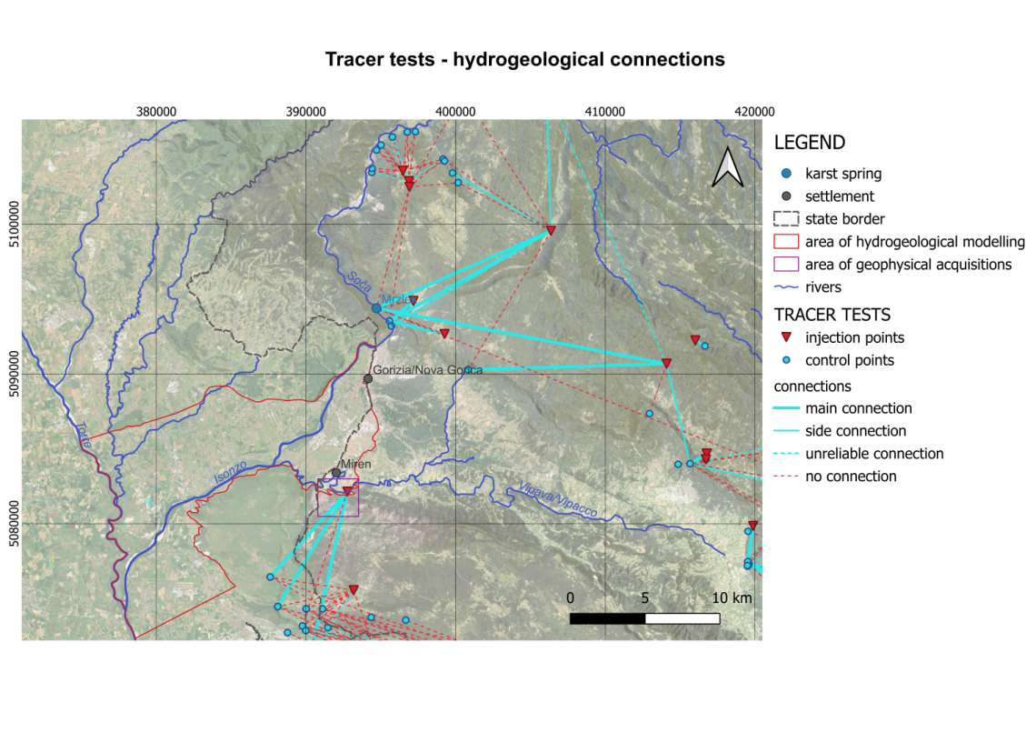
The map presents the results of tracer tests conducted in the study area (the Slovenian side) over the past decades. The red triangles indicate the injection points, where tracers were introduced into the system (e.g., caves, sinkholes, and other infiltration points). The turquoise dots represent the monitoring points (springs, rivers, caves, etc.) where water samples were collected to detect the arrival of the tracer. The turquoise lines show the identified hydrogeological connections between locations, distinguishing between main, secondary, and uncertain connections. The red dashed lines indicate that no hydrogeological connection was detected between the corresponding points. Tracer tests are one of the primary tools in karst hydrogeology for investigating groundwater flow paths and improving the understanding of the hydrogeological setting and functioning of karst systems.
Status of groundwater bodies and water quality monitoring sites in the study area (Italian side)
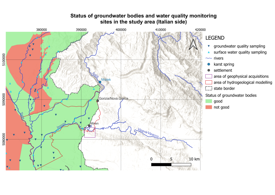
This map presents the chemical status of groundwater bodies and the locations of water quality monitoring sites on the Italian side of the study area. A comparable database was not publicly available for the Slovenian side.
The dark blue triangles represent groundwater quality monitoring sites, while the light blue triangles indicate surface water quality monitoring sites.
The status of the groundwater bodies is classified into two categories: good and poor (not good). The water quality data for both surface water and groundwater provide valuable information on the current state of water resources and highlight key issues related to water availability, quality, and long-term sustainability in the region.
Mean annual air temperature of the study area
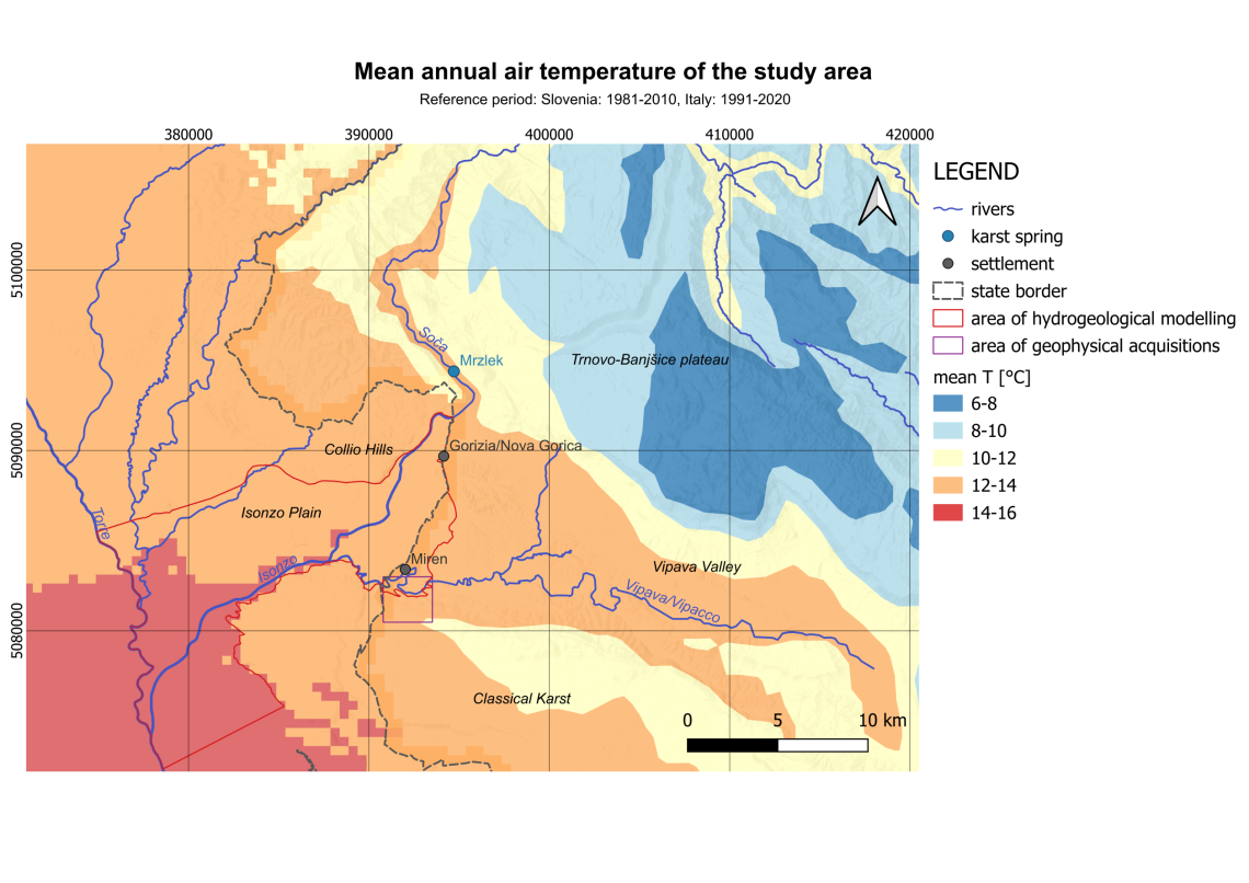
This map illustrates the mean annual air temperature distribution across the study area, including regions such as the Isonzo Plain, the northwestern part of the Classical Karst, and the Vipava Valley.
It is evident that the available data are not fully homogeneous across the Italian and Slovenian sides of the study area, particularly with regard to data resolution and reference periods. The temperature data are based on the 1981–2010 reference period for Slovenia and the 1991–2020 reference period for Italy.
The map shows mean annual temperatures ranging from approximately 6°C in the mountainous areas to 16°C in the lowlands, highlighting the spatial variability of climatic conditions across the region.
The meteorological setting forms an important part of the environmental framework within which the study results can be interpreted. In addition, temperature data can serve also as input data for certain modelling tasks.
Mean annual precipitation of the study area
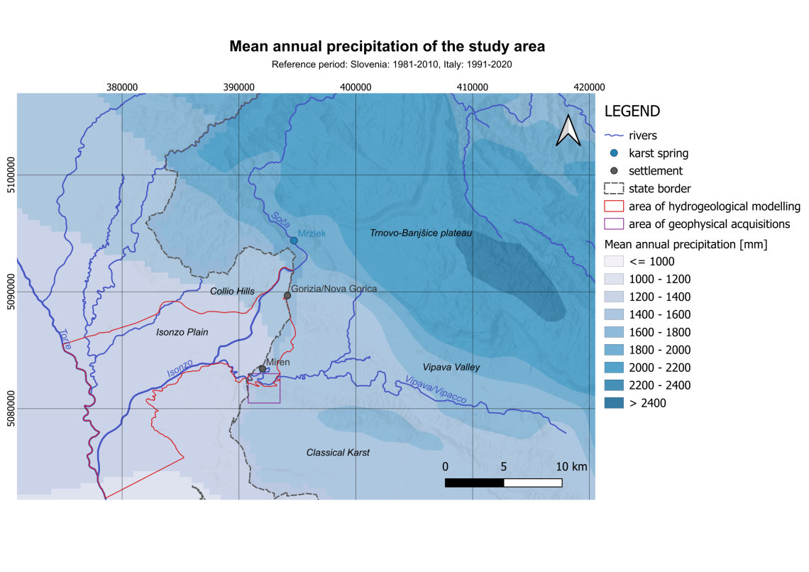
This map illustrates the distribution of mean annual precipitation across the study area, including regions such as the Isonzo Plain, the northwestern part of the Classical Karst, and the Vipava Valley.
It is evident that the available data are not fully homogeneous across the Italian and Slovenian sides of the study area, particularly with regard to data resolution and reference periods. The precipitation data are based on the 1981–2010 reference period for Slovenia and the 1991–2020 reference period for Italy.
The map shows mean annual precipitation ranging from more than 2,400 mm/year in the mountainous areas to less than 1,000 mm/year in the lowlands, highlighting the spatial variability of climatic conditions across the region.
The meteorological setting forms an important part of the environmental framework within which the study results can be interpreted. In addition, precipitation data can serve also as input data for certain modelling tasks.
The complete GIS database is available upon request.