The catastrophic fires of summer 2022 on the Karst — lasting days and fought by firefighters who came from across Europe — were not an isolated incident. Since then, the Karst Firewall 5.0 project, co-financed by the European Union under the Interreg Italy-Slovenia programme, has been working on a shared tool between the two countries to prevent them. On 17 March, in a hall in Duino Aurisina, a workshop evening put that tool in the hands of those who live and work on the Karst.
A warmer climate, an ever-longer summer
Weather stations in the area now record almost two degrees more than in the 1990s, with a new record in 2024 in both Italy and Slovenia. Summer is by far the most dangerous season for fires on the Karst — it concentrates nearly half of all historical events — and warming is making it worse: the ground dries out earlier, vegetation is less resistant, and the window of risk grows longer.
What makes an area vulnerable
The first cross-border Karst fire database compiles 1,446 geolocated events over thirty years, unifying Italian and Slovenian archives that until now spoke different languages: different coordinates, different frequencies, even the definition of "fire" was not the same on either side of the border. The numbers reveal new things. Eighty percent of fires break out in the same areas, year after year. Eighty-four percent start within 500 metres of a road or railway. Three quarters have a human origin, often not through deliberate action but through small infrastructure-related accidents: a spark from a train, a cigarette butt thrown in passing. What is predictable can be prevented.
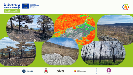
A platform to show where to look
The tool developed by the project and presented in Duino Aurisina brings three things together: historical data, sensors and predictive models. In the field, twenty-two weather stations have been recording temperature, humidity, rainfall, wind, pressure and solar radiation since 1991. These are complemented by small sensors developed within the project, solar-powered and capable of operating for months in remote areas without Wi-Fi. From above, the Sentinel satellites of the European Copernicus programme regularly update maps of vegetation and soil, while drones are used for targeted monitoring of the most sensitive areas.
All this data feeds a model that, every morning, divides the Karst into forty thousand cells and answers one question for each: today, here, how likely is a fire? The result is a three-colour map — red, yellow, green — that immediately shows where to focus attention. A system based on weather data alone intercepted twenty-nine fires out of a hundred; this one intercepts seventy-seven.
Three tables, three perspectives
On 17 March, in a hall in Duino Aurisina, around twenty-five people gathered around three tables. At the first, firefighters; at the second, civil protection technicians; at the third, residents — people who have lived on the Karst their whole lives. The task was the same for every group: mark with post-its where the land catches fire first, and say why. The final maps, however, are three, because each table looks at the same landscape through different eyes. From the groups emerges a Karst made not only of burning vegetation: habitat conservation, the maintenance of roads at the edge of the forest, firebreaks yet to be completed, areas where clearance of unexploded ordnance from the Great War is still needed.
The final survey says two things. First: 71% of participants consider the platform "broadly consistent" with the critical areas identified at the tables. Second: the main limitation, according to more than one in two participants, is not about technology but about coordination between institutions — managing a fire on the border means moving people, equipment and decisions that follow different rules on either side.
Beyond the border
One of the founding choices of the project is precisely this: keeping Italy and Slovenia together on a problem that respects no national borders. Fires that start on one side of the Karst can spread to the other — and in the summer of 2022 they did so dramatically. Building shared datasets, harmonising methods and developing joint action plans is the first step towards coordinated management involving researchers, firefighters, local administrators, land managers and communities. A second meeting of the same kind was held in April on the Slovenian side of the border, in Koper. Next summer, the platform will be fully operational on the Karst.