Home
  • it
  • sl
  • en

Area riservata

  • Reserved Area

Navigazione principale

  • Programme
    • About Interreg IT-SI
      • Latest update
      • Financial allocation
      • Partnership involvement
      • Communication approach
      • Legislative framework
      • Other informations
      • Transparent Administration
    • Programme Area
    • Authorities and structures
    • Objectives
      • A smarter Europe
      • A greener Europe
      • A more social Europe
      • A better governance
    • Documents
      • Interreg Programme
      • Legislation
      • Monitoring Committee Documents
      • Italy-Slovenia Border Orientation Paper
      • Communication & visibility
      • Analysis documents
      • SEA Procedure
      • Environmental monitoring
      • State Aids
      • Management and control
      • Progamme Evaluation
      • Post 2027
    • Publications
    • Other programming periods
    • Privacy
    • Youth
      • Students4Cooperation
        • Guidelines and documents
        • Project ideas
        • Photos and videos
    • Synergies
      • Synergy map
      • MMM
      • Success stories
      • OSI Event
  • Projects
    • Financed projects
    • Project typologies
      • Strategic projects
      • Capitalization projects
      • Standard projects
      • Small scale projects
    • Project implementation
      • Communication
      • Expenditures and reporting
      • Project variations
      • Project closure
      • Videos and tutorials
      • Circular letters
    • Visual identity
    • SPF
    • FAQ
  • News & Events
    • News
    • Procurement and notices
    • PROJECT EVENTS
    • PROGRAMME EVENTS
    • INTERREG GO!
      • AGENDA
      • VENUES
      • PROJECT VISITS
      • YOUTH SIDE EVENT
        • Students4Cooperation
        • Interreg GO! Youth Event
      • NEWS
      • PHOTOS
      • CONTACTS
  • MEDIA GALLERY
  • Calls
    • Open calls
    • Closed calls
  • Contacts
  • Jems
  • 2028-2034
    • 2028–2034
      • Documents
      • Legislative framework
      • Planning phase
      • Learn more
  • it
  • sl
  • en
Follow us

Main navigation

  • Programme
  • Projects
  • News & Events
  • MEDIA GALLERY
  • Calls
  • Contacts
  • Jems
  • 2028-2034

Main navigation

  • News
  • Procurement and notices
  • PROJECT EVENTS
  • PROGRAMME EVENTS
  • INTERREG GO!

When water draws paths through vineyards: science in the fight against erosion

The ERO-Stop project concludes today, a two-year collaboration between diverse partners from Italy and Slovenia with a common goal: managing erosion processes in agricultural land. Italy and Slovenia are among the European countries most exposed to the risk of erosion. The causes are partly linked to the morphology of the land and the geological structure of the soil, partly to changing rainfall patterns, and, last but not least, to human intervention through land transformation and cultivation techniques.

Interdisciplinary projects are always challenging, as they require, first and foremost, the ability to listen and understand one another. It is necessary to understand and embrace the working methods of different disciplines and be aware of the regulatory specificities of the various fields. Learning from one another allows us to identify synergies between the partners' expertise and to chart new operational prospects. ERO-Stop was precisely such a project. We conclude with the knowledge that we have made concrete steps in some areas and, in others (for example, in terms of regulation), have at least indicated the direction of necessary future developments. We are enriched with knowledge that will contribute to making agricultural soils more resistant to erosion, as well as with long-lasting professional relationships.

As researchers, we are particularly motivated by the search for new approaches and possibilities in addressing scientific challenges. In an age of numerous technological opportunities, research sometimes resembles a building block game: integrating data obtained from different measurement methods, combined with IT tools, to produce a useful picture for the end user.

The Slovenian partners analyzed erosion resistance in three pilot vineyards, differing in age (vegetation cover and soil compaction), slope, size, and morphological complexity. Data on soil morphology were acquired through highly precise drone surveys, soil properties through laboratory analysis of soil samples, while water infiltration capacity was assessed through field measurements.

The first numerical simulations of erosion processes were performed using the established RUSLE (Revised Universal Soil Loss Equation) method, an empirical approach aimed at estimating soil erosion susceptibility. However, this method does not take into account local aspects such as preferential flow paths. Subsequently, the SIMWE (SIMulated Water Erosion) method, based on the continuity equations of water flow and sediment transport, was also applied. It emerged that, although this method requires some parameters that are difficult to determine and therefore does not yet allow for a fully reliable estimate of the amount of erosion, it does represent the flow paths of water and sediment very effectively. This information is directly applicable to drainage planning.

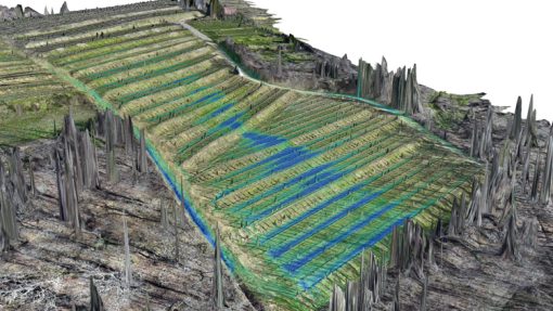
Both methods were implemented in a GIS environment, allowing for a clear and intuitive representation of the results and the identification of the points most exposed to erosion risk. The images shown show the height of the water blade calculated during a heavy rainfall event (100 mm/h) in the vineyards of Plače, Zavino, and Velike Žablje.

Image
Quando l’acqua disegna percorsi tra i vigneti: la scienza nella lotta contro l’erosione

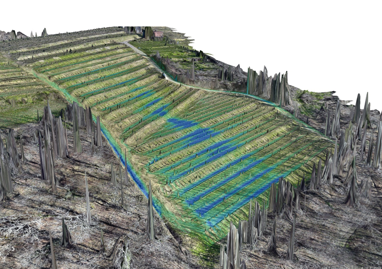
Figure 1: Numerical simulation of the water blade height during an extreme precipitation event in the Plače vineyard

Image
Oggi si conclude il progetto ERO-Stop, una collaborazione biennale tra partner eterogenei di Italia e Slovenia con un obiettivo comune: la gestione dei processi erosivi nei terreni agricoli. Italia e Slovenia rientrano tra i Paesi europei maggiormente esposti al rischio di erosione. Le cause sono in parte legate alla morfologia del territorio e alla struttura geologica dei suoli, in parte al mutato regime delle precipitazioni e, non da ultimo, all’intervento umano attraverso le trasformazioni del territorio

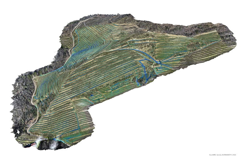
Figure 2: Numerical simulation of the water blade height during an extreme precipitation event in the Zavino vineyard

Image
Oggi si conclude il progetto ERO-Stop, una collaborazione biennale tra partner eterogenei di Italia e Slovenia con un obiettivo comune: la gestione dei processi erosivi nei terreni agricoli. Italia e Slovenia rientrano tra i Paesi europei maggiormente esposti al rischio di erosione. Le cause sono in parte legate alla morfologia del territorio e alla struttura geologica dei suoli, in parte al mutato regime delle precipitazioni e, non da ultimo, all’intervento umano attraverso le trasformazioni del territorio

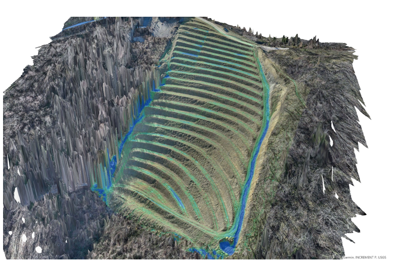
Figure 3: Numerical simulation of the water blade height during an extreme precipitation event in the Velike Žablje vineyard

ero-stop
Quando l’acqua disegna percorsi tra i vigneti: la scienza nella lotta contro l’erosione
published on 14. 4. 2026

Programme

  • About Interreg IT-SI
  • Programme Area
  • Authorities and structures
  • Objectives
  • Documents
  • Publications
  • Other programming periods
  • Privacy
  • Youth
  • Synergies

Projects

  • Financed projects
  • Project typologies
  • Project implementation
  • Visual identity
  • SPF
  • FAQ

News & Events

  • News
  • Procurement and notices
  • PROJECT EVENTS
  • PROGRAMME EVENTS
  • INTERREG GO!

Mediagallery footer

  • Media gallery

Calls

  • Open calls
  • Closed calls

Contatti footer

  • Contacts

Preferenze sui Cookies

  • Cookie Settings
Follow us

This website is co-financed by the European Union in the framework of the Interreg VI-A Italy-Slovenia 2021-2027 programme